 Received on 24 May 2011 from the City of Toronto, two distinct and complete 2009 colour orthoimagery data sets for the entire City of Toronto. The first data set consists of 5,754 tiles each covering an area of 0.5 km2 and with an image resolution of 10cm ground. The second set is an orthomosaic with image resoulution of 40cm.
Wednesday, August 31, 2011
City of Toronto 2009 Orthoimagery
Received on 24 May 2011 from the City of Toronto, two distinct and complete 2009 colour orthoimagery data sets for the entire City of Toronto. The first data set consists of 5,754 tiles each covering an area of 0.5 km2 and with an image resolution of 10cm ground. The second set is an orthomosaic with image resoulution of 40cm.
Friday, August 26, 2011
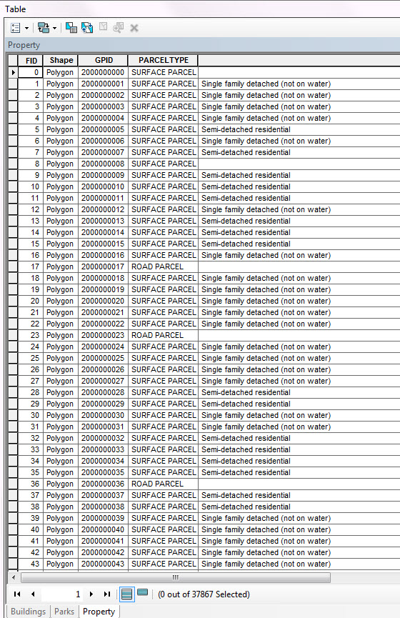
City of Toronto: Property Data Maps
 Received on 24th of May 2011 from the Geospatial Competency Centre, Mapping Services, City of Toronto, an updated set of tiled Toronto Property Data maps (PDMS) with print date of Feb 2011.
Thursday, August 18, 2011
City of Guelph 2011 Municipal Data

Received June 9, 2011 updated municipal data, including a new property/ building type file not previously available from the 2006 data release.
Wednesday, August 17, 2011
Simply Map Canada 2.0
 SimplyMap Canada is being upgraded from 1.0 to 2.0 and will be available early September, 2011. New version available for trial from August 18, 2011 to September 5, 2011 at: http:sm2.simplymap.com
Monday, August 15, 2011
RMOW street network

Received on May 24th, 2011, single line street network shapefile from the Regional Municipality of Waterloo. Shapefile has the same rich attribute information as earlier editions.
Subscribe to:
Posts (Atom)


